A team of scholars from the University of Maine, Duke University and Washington University in St. Louis has won a 2018 Digital Humanities Advancement Grant from the National Endowment for the Humanities.
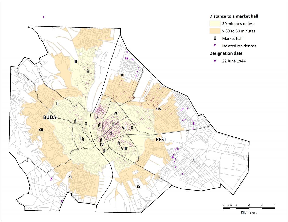
The three-year, $296,455 grant will support “The Holocaust Ghettos Project: Reintegrating Victims and Perpetrators through Places and Events.” Part of the Holocaust Geographies Collaborative, the project will use information from the United States Holocaust Memorial Museum’s Encyclopedia of Camps and Ghettos to create a historical geographic information system (GIS) model of 1,400 Nazi-era Jewish ghettos.
This GIS will enable the first systematic, comparative analysis of Jewish ghettos, forced labor and mass murder in Eastern Europe from 1939-45. The project also will incorporate post-war interviews in which survivors describe their experiences, and will allow scholars to analyze the relationships between perpetrators and victims using geospatial methods.
“Our place-based model of the Holocaust is intended to bridge the long-standing divide in Holocaust studies between victims and perpetrators by locating them together in places targeted by ghettoization," said project director Anne Knowles, the Colonel James C. McBride Distinguished Professor of History at the University of Maine.
Also leading the team are Washington University’s Anika Walke, assistant professor of history in Arts & Sciences, and Paul Jaskot, professor of art, art history & visual studies at Duke University, who serve as co-directors. Other contributors include geographers and historians at Stanford University, Texas State University, Bristol University and the University of Maine.
Once the GIS is complete, researchers will use geovisualization — the display of information that has a geospatial component — to explore spatial patterns and physical characteristics of ghettos; to reconstruct victims' movements; and to connect individual trajectories to larger events that forced millions from their homes.
“Scholars still debate whether Nazi policies were developed systematically or on an ad-hoc basis,” Walke said. “We can show how local conditions both determined and reflected exploitation and extermination practices that unfolded differently across the German-occupied territories.
“The project also will allow us to better analyze the Jewish experience of ghettoization, such as opportunities for survival and resistance, in different places and under distinct conditions,” Walke said.